Planning for Section A is somewhat completed. By the way, that's section A for Southern California. The sections in the book I'm using break down like this:
Southern Cal: A-H
Northern Cal: I-R
Oregon and Washington: A-L
The following is the breakdown of Section A.
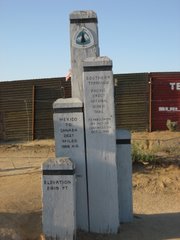
Day 1: Mexico border to Lake Moreno Campground
20.6 miles
This will take me from 2900' (altitude) down below 2400' and back up to 3400' before settling at 3065'.
I will camp here at Moreno for the night and I would welcome anyone to come join me. I'll carry limited food as I will resupply in camp.
Day 2: Lake Moreno Campground to Cibbits Flats Campground
12 miles
3065' to 4410'
Day 3: Cibbits Flats to Mt. Laguna
10 miles
4410' to up over 6000'
I will stay in a room with a bed in Mt. Laguna.
Day 4: Mt. Laguna to Pioneer Mail Trailhead
9.5 miles
6000' to 5260'
Day 5: Pioneer Mail Trailhead to Rodriguez Spur Truck Road
15.7 miles
5260' down and up and down to 3650'
Day 6: Rodriguez Spur Truck Road to Top of San Felipe Hills
17 miles
3650' down to 2250' and up to 3360'
Day 7: Top of San Felipe Hills to San Ysidro Creek
20.2 miles
3360' up to 4395' and down to 3355'
Day 8: San Ysidro Creek to Warner Springs
4.4 Miles
3355' over 3500' and back down to 3010'
This section is mostly dry underbrush with little water and can be very hot. There are two 24 mile waterless stretches. This doesn't mean there will be no water, just no guarantee of water. Creeks are usually dried up by spring, however there are volunteers who leave water for hikers. As you can see, this section undulates gradually up and down. One of the more interesting concerns is the illegal aliens who will be passing my tent in the dark along the way.
I look forward to knowing this is behind me. I will enjoy the forest sections much more than the desert for the most part.
18.12.07
7.12.07
Planning, planning, planning
I've learned a bit by planning my little walk. What I've learned is to plan about two or three weeks and then review and break it down as groups of days and then to break it down to individual days before considering it semi-planned. I say semi-planned because after you plan the whole event, you go out and start walking and throw most of your exact plans out the window. This is based on day to day weather, trail closures, and things like your feet.
Primarily the planning breaks down to a resupply plan. Of course of utmost concern is to know where and when you will be near sources of water, but the resupply lines for food and equipment are fairly darn important as well. So, here's some notes:
1. You need water. Water is critical. Water will be in your backpack. 3 to 6 liters of it most of the time. Water weighs over 2 pounds per liter and thus you will be carrying 6 and a half to 13 pounds of water at any given time.
2. The first 200 miles of the PCT are in desert climates that are often in the triple digit temperature range in the spring. Thus you may need more water than mentioned in number 1.
3. Resupply includes food. This can be shipped ahead when it is dehydrated and purchased at stores along the way. Gaps between resupply points can be 20-45 miles so you will often carry 2-3 days of food. When hiking 20 miles a day you often burn 5-6 thousand calories per day. Resupply should include good amounts of HIGH calorie food. Oh and there's sections where the resupply points are further apart. More on that later.
4. Resupply includes equipment. The hike is 2,660 miles. Shoes last about 400 miles. That's right, I'll be mailing shoes to myself. Also, I will be hiking in the desert and atop snow covered mountains at 12,000 feet. This requires very different types of equipment. Carrying all of this at one time would destroy me. Therefore I'll be planning where I need boots, clothes, jackets, crampons, etc. and shipping them to me.
I sort of feel like I'm planning to invade Canada, not just walk to it.
Subscribe to:
Posts (Atom)