Planning for Section A is somewhat completed. By the way, that's section A for Southern California. The sections in the book I'm using break down like this:
Southern Cal: A-H
Northern Cal: I-R
Oregon and Washington: A-L
The following is the breakdown of Section A.
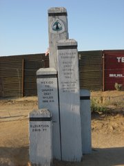
Day 1: Mexico border to Lake Moreno Campground
20.6 miles
This will take me from 2900' (altitude) down below 2400' and back up to 3400' before settling at 3065'.
I will camp here at Moreno for the night and I would welcome anyone to come join me. I'll carry limited food as I will resupply in camp.
Day 2: Lake Moreno Campground to Cibbits Flats Campground
12 miles
3065' to 4410'
Day 3: Cibbits Flats to Mt. Laguna
10 miles
4410' to up over 6000'
I will stay in a room with a bed in Mt. Laguna.
Day 4: Mt. Laguna to Pioneer Mail Trailhead
9.5 miles
6000' to 5260'
Day 5: Pioneer Mail Trailhead to Rodriguez Spur Truck Road
15.7 miles
5260' down and up and down to 3650'
Day 6: Rodriguez Spur Truck Road to Top of San Felipe Hills
17 miles
3650' down to 2250' and up to 3360'
Day 7: Top of San Felipe Hills to San Ysidro Creek
20.2 miles
3360' up to 4395' and down to 3355'
Day 8: San Ysidro Creek to Warner Springs
4.4 Miles
3355' over 3500' and back down to 3010'
This section is mostly dry underbrush with little water and can be very hot. There are two 24 mile waterless stretches. This doesn't mean there will be no water, just no guarantee of water. Creeks are usually dried up by spring, however there are volunteers who leave water for hikers. As you can see, this section undulates gradually up and down. One of the more interesting concerns is the illegal aliens who will be passing my tent in the dark along the way.
I look forward to knowing this is behind me. I will enjoy the forest sections much more than the desert for the most part.
In the blog on Scott's attempt to hike the National Pacific Crest Trail, Scott is represented by two separate yet equally important groups: the people who have hiked this trail before and the people who will support Scott in his new quest. These are their stories. [Dunh-Dunh]
Links to Info
Journals of Note
Always bear in mind that your own resolution to succeed is more important than any one thing.
-Abraham Lincoln
No comments:
Post a Comment