Planning for Section A is somewhat completed. By the way, that's section A for Southern California. The sections in the book I'm using break down like this:
Southern Cal: A-H
Northern Cal: I-R
Oregon and Washington: A-L
The following is the breakdown of Section A.
Day 1: Mexico border to Lake Moreno Campground
20.6 miles
This will take me from 2900' (altitude) down below 2400' and back up to 3400' before settling at 3065'.
I will camp here at Moreno for the night and I would welcome anyone to come join me. I'll carry limited food as I will resupply in camp.
Day 2: Lake Moreno Campground to Cibbits Flats Campground
12 miles
3065' to 4410'
Day 3: Cibbits Flats to Mt. Laguna
10 miles
4410' to up over 6000'
I will stay in a room with a bed in Mt. Laguna.
Day 4: Mt. Laguna to Pioneer Mail Trailhead
9.5 miles
6000' to 5260'
Day 5: Pioneer Mail Trailhead to Rodriguez Spur Truck Road
15.7 miles
5260' down and up and down to 3650'
Day 6: Rodriguez Spur Truck Road to Top of San Felipe Hills
17 miles
3650' down to 2250' and up to 3360'
Day 7: Top of San Felipe Hills to San Ysidro Creek
20.2 miles
3360' up to 4395' and down to 3355'
Day 8: San Ysidro Creek to Warner Springs
4.4 Miles
3355' over 3500' and back down to 3010'
This section is mostly dry underbrush with little water and can be very hot. There are two 24 mile waterless stretches. This doesn't mean there will be no water, just no guarantee of water. Creeks are usually dried up by spring, however there are volunteers who leave water for hikers. As you can see, this section undulates gradually up and down. One of the more interesting concerns is the illegal aliens who will be passing my tent in the dark along the way.
I look forward to knowing this is behind me. I will enjoy the forest sections much more than the desert for the most part.
18.12.07
7.12.07
Planning, planning, planning
I've learned a bit by planning my little walk. What I've learned is to plan about two or three weeks and then review and break it down as groups of days and then to break it down to individual days before considering it semi-planned. I say semi-planned because after you plan the whole event, you go out and start walking and throw most of your exact plans out the window. This is based on day to day weather, trail closures, and things like your feet.
Primarily the planning breaks down to a resupply plan. Of course of utmost concern is to know where and when you will be near sources of water, but the resupply lines for food and equipment are fairly darn important as well. So, here's some notes:
1. You need water. Water is critical. Water will be in your backpack. 3 to 6 liters of it most of the time. Water weighs over 2 pounds per liter and thus you will be carrying 6 and a half to 13 pounds of water at any given time.
2. The first 200 miles of the PCT are in desert climates that are often in the triple digit temperature range in the spring. Thus you may need more water than mentioned in number 1.
3. Resupply includes food. This can be shipped ahead when it is dehydrated and purchased at stores along the way. Gaps between resupply points can be 20-45 miles so you will often carry 2-3 days of food. When hiking 20 miles a day you often burn 5-6 thousand calories per day. Resupply should include good amounts of HIGH calorie food. Oh and there's sections where the resupply points are further apart. More on that later.
4. Resupply includes equipment. The hike is 2,660 miles. Shoes last about 400 miles. That's right, I'll be mailing shoes to myself. Also, I will be hiking in the desert and atop snow covered mountains at 12,000 feet. This requires very different types of equipment. Carrying all of this at one time would destroy me. Therefore I'll be planning where I need boots, clothes, jackets, crampons, etc. and shipping them to me.
I sort of feel like I'm planning to invade Canada, not just walk to it.
28.11.07
New map link
Here's a great Google Map of the PCT. You can look at it through the satellite or standard view as well as zoom in on it, etc. I will also put this on the side bar.
Okay desert, here I come.
So, the Cleveland, Angeles, and San Bernadino National Forests are all closed to ALL recreation due to fire hazards. Let me just make a quick note to eliminate ALL the forests near me for hikes in the near future.
I want to go on a overnighter in the next couple of weeks to see how warm my sleeping bag is and how warm my thermo vest+wind shell combo is. I will definitely take some emergency clothes and some hot tea with me because the desert is known to get a little cold at night.
Alright, who's going with me?
26.11.07
So, um yeah
I know I haven't posted. The task of planning out such an epic journey is daunting. Also, I need to post corrections already. It seems I haven't hiked for quite some time. I've also put on weight. Well, that ends now. I'm elated by the recent weather. I know most of you think I'm crazy but, highs in the 40's and lows in the 10's are motivating to me. I will plan my next hike in the next day or so and will get back to epic trail planning as well. More notes soon.
17.9.07
Hike Planning Day 1
Tonight I began planning the hike. Here's the first 3 days.
Day 1 and 2
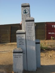
The first morning will start early at the Mexican border. A short moment for pictures at the Southern Terminus of the PCT monument and time for a few words written into the register. Then I will begin a 17 mile hike to Lake Moreno campground. This hike is an up and down gradual grind. The first 2 miles include a 500 foot descent followed by a 1000' climb over the next 6 miles. At this point I'll have beautiful views for the next mile of the next 1000' descent and 1000' foot climb over the next 7 miles. I have an opportunity to camp at the base of this canyon but hope I will make it up to the peak as the Lake Moreno Campground is 3/4 mile from the peak. I will camp in Moreno till morning of day 3.
Day 3
On this day I will start early on an 18 mile hike that will take me grinding up 3000'. It is a full day of nothing but unrelenting climbing. The first of a few along the trip. Fortunately this is only 3000' up. I will camp in Lower Morris Meadow where the guide says a beautiful camp awaits.
With mostly drought years recently, I can plan on few water sources. There are three campgrounds along these first 35 miles of the trip that I can count on to have water. There may be a seasonal spring or two, but nothing guaranteed and therefore I cannot plan for these. Therefore I will carry at least 8 liters of water per day. This is roughly 16 pounds of water per day. This will be on top of the weight of my pack, supplies, food, and clothes. Probably putting my pack around 35-40 pounds for this stretch.
Alternatively, a solid winter will provide water, but will mean the hills that I summit will have snow to slog through.
The first 200 miles of the hike are often the proving ground. It is all desert and mountains. If I can make it through this section, I can start feeling confident about my chances.
Day 1 and 2
The first morning will start early at the Mexican border. A short moment for pictures at the Southern Terminus of the PCT monument and time for a few words written into the register. Then I will begin a 17 mile hike to Lake Moreno campground. This hike is an up and down gradual grind. The first 2 miles include a 500 foot descent followed by a 1000' climb over the next 6 miles. At this point I'll have beautiful views for the next mile of the next 1000' descent and 1000' foot climb over the next 7 miles. I have an opportunity to camp at the base of this canyon but hope I will make it up to the peak as the Lake Moreno Campground is 3/4 mile from the peak. I will camp in Moreno till morning of day 3.
Day 3
On this day I will start early on an 18 mile hike that will take me grinding up 3000'. It is a full day of nothing but unrelenting climbing. The first of a few along the trip. Fortunately this is only 3000' up. I will camp in Lower Morris Meadow where the guide says a beautiful camp awaits.
With mostly drought years recently, I can plan on few water sources. There are three campgrounds along these first 35 miles of the trip that I can count on to have water. There may be a seasonal spring or two, but nothing guaranteed and therefore I cannot plan for these. Therefore I will carry at least 8 liters of water per day. This is roughly 16 pounds of water per day. This will be on top of the weight of my pack, supplies, food, and clothes. Probably putting my pack around 35-40 pounds for this stretch.
Alternatively, a solid winter will provide water, but will mean the hills that I summit will have snow to slog through.
The first 200 miles of the hike are often the proving ground. It is all desert and mountains. If I can make it through this section, I can start feeling confident about my chances.
26.8.07
Ahh, new discoveries.


Discovery number one: I can go on a long hike and not have to twist my ankle every mile or so.
Discovery number two: Bobbi bought a pad to sleep on with three requirements; it be soft, it fit her sleeping bag, and it be pink. I bought a pad with two requirements; it be light and keep me warm. Discovery, Bobbi bought a nice comfortable pad, and I wake up every 30 minutes.

Discovery number three: Although I have a ways to go in conditioning, I really think I can do this border to border hike.

We hiked this weekend in our regular spot. The PCT above Wrightwood to Jackson Flats campground. This time with the added twist of spending the night and waking up to hike 8 more miles (it's about 2.5 miles to Jackson Flats). The hike was pretty nice, we had great weather and although I didn't sleep well on the pad, all of my other equipment worked well.
I have a new stove that boils 2 cups of water in about 20 seconds, and a sleeping pad and bag combo. I say combo because the bag has no down or insulation underneath, instead it has a sleeve for a sleeping pad to slide into and insulate underneath you. This is a stellar idea as down stuffing does nothing to pad you and thus you reduce some weight as you'll have a pad anyways. These all worked great except I may have to adjust to the bad or splurge for a softer heavier one.
Also, I got to use my trekking poles again. These were bought by Bobbi and are my favorite hiking items. They create a lot of stability while transferring some load off of your legs and back, into your arms. This allows you to go much farther and faster in my opinion. Although a trekking pole-less Bobbi still kicks my butt's pace.
Here's some pics from the hike. Also, I will start planning my PCT thru hike in the next week, doing a small section each week. I will post this process and my thoughts as I go.
19.8.07
Well, the doc said to go...
We're going for an over-nighter next weekend. My Physical Therapist wants me to put at least 10 miles on my ankle without my brace, but he suggested I put the brace in my backpack, just in case. Depending on the weather, we're going to hike above Big Bear. There's a great little campground hidden in a lush creek. I'm very excited. Obviously, I'll finally have more to write about.
17.7.07
The foot
Well, the foot handled the hike this weekend well. Of course I was wearing a brace. Hiking puts your mind into interesting places. We hiked (Bobbi and I) about 3 miles. My foot did not hurt at all, but I did get a deep aching in my right shoulder under my backpack strap. I also felt my sunburn from the 4th of July sting a bit. The point here is that this pain gets compartmentalized. It is as if there were two of me hiking Sunday. I have read that many hikers talk about the trance-like state your mind enters. You see, there was the guy hiking the trail, enjoying the outdoors and the view and just "being there". There was also the guy who noticed the pain in my shoulder, felt the sting on my sunburn, and choked in the heat between breezes, but this part of me felt like it was somewhere else. We'll see if this guy starts to push into my brain and speak a little louder when we hike more miles. I know he interrupted my hike with Bobbi in Big Bear and battled the "Lizard of Hope" for dominance a month or two ago.
Continuing with my foot, we have a series of exercises to do 3 times a day to strengthen the stabilizer muscles. This should compensate for the bad ligaments. I will be seeing my physical therapist "Nathan" every 2 weeks for the next month. By the way, if you have an injured toe, as I do, there may be no worse pain in this world then the towel crawl excercise. The way this works is you sit in a chair and lay a towel on the tile floor flat away from your foot. You then use your toes to scrunch the towel slowly towards you, pulling the full length in without using the rest of your foot. Repeat 5 times and scream a little.
Well, today is my birthday and we're off to REI tonight to do some shopping. I will have gear updates shortly. Also, some pics from this weekend will pop up soon.
11.7.07
Okay, the ligament is bad but workable
It looks like the ligament in my foot has been my problem for years. Good news is, on Monday we will be seeing the physical therapist, and we have a very effective brace. Result of all this, is that I will be hiking this Sunday. Stay tuned.
18.6.07
Stupid foot...
Well, if your wondering why the nes here has slowed to a crawl, blame my stupid foot. I tend to roll over my right foot, (called over pronation), and stumble a lot. While not the best experience for hiking, it has been manageable up till now. Approximately 2 days after setting a doctor's appointment to look into this problem, I stumbled down 4 stairs on top of my big toe. Did I mention I was carrying a couch when I performed this "April-like" manuever? Haven't been able to really walk right since. If I was on the trail at this moment, there would be a daily dose of Ibuprofen and the hopes of fighting through the pain. As I am not on the trail, proper healing is the call.
So the Doc looked at my toe and said, "I don't . . . think . . . it's broken, but I think you should see a podiatrist about all of this. I'll refer you and he'll setup an appointment in the next few weeks."
So, I'm waiting for a call. Of course, the toe gets worse every day. I could call and see my doc again sooner, but who wants to pay $30 to be told to wait for the podiatrist?
8.6.07
Other Thru Hikes. . .
Some other notable thru hikes in the U.S. are now posted on the right side as well as linked here with some quick facts.
ADT - American Discovery Trail: Depending on your route this is either 5,057 miles or 4,834 and crosses the U.S. from the Atlantic to the Pacific
AT - Appalachian Trail: A 2,175 mile hike from Maine to Georgia known as the Green tunnel for it's length of tree shaded trail.
CDT - Continental Divide Trail: 3,100 miles from Mexico to Canada along the Spine of the Rocky Mountains. This trail is only 70% usable at this time and will be celebrating its 30th anniversarry next year.
4.6.07
Putting off hiking
Well, won't be hiking this week due to the moving. We're moving into the kind of house that begs you to lazily sit by the fire pit or pool and eat cheese and drink wine. Begs you to sleep on a lounge chair nibbling on the grapes hanging from the patio trellis. Not the kind of house that says, "Get out there and get some exercise."
More updates to come.
More updates to come.
31.5.07
Walking The West
This film is about two thru-hikers who hit the trail in 1998. I purchased it and will happily loan it to any friend who asks. This isn't the most beautifully photographed documentary, nor is it the most compelling told story, but it does show the actual process of this hike. There's the "I'm going to do this PCT hike", "We're planning and packing and shipping food", and "We're hitting the trail" portions of the story. Most interesting is that one of the two doesn't make it. Why is this interesting? He makes it 2,561 miles and then drops out before the last 62 miles (the trail has changed length since this time due to new routes). Now, I'm not criticizing the guy because after all he hiked 2,5621 miles and that's amazing. His feet were torn up and blistered and he was cold. He probably could have went back a week later and finished but he didn't. This is a testament to the trail and it's difficulty.
Meanwhile in the same film we see a 78 year old man finish the trail. How beautiful is that? I thought about this for a while and my conclusion is that it's about personal motivation. I have not always been the type that fought the long fight, or saw the gains in long term sacrifice. Isn't it easier just to go out for coffee and read a book after all? This however is something I want to do and must do. I will plan this hike better than those in the film (I think they tried to go too fast), I will train better (doing long term hikes a week or two long before I go), and I will not take no for an answer when my feet and body throw it at me.
The hike is said to be 80% mental and 20% physical because it's such a physical pounding that your mind has to overcome the consistent pain. Here's some fun facts:
- It was recently pointed out that fewer people have thru-hiked the PCT than have climbed Mt. Everest!
- The trail doesn't actually end at the Canadian border but continues for another 9 miles into Manning Provincial Park, British Columbia. Thus I need to update my passport.
- In spring 2003, the Travel Channel chose the Seiad Valley Cafe (in Seiad Valley, near Calif./Ore. border) as the third best location in the world to "pig out." They were referring, of course, to the cafe's great "pancake challenge" which tempts hungry thru-hikers to finish a mammoth stack of pancakes in one sitting.
- The PCT passes the three deepest lakes in the nation; Lake Tahoe (1,645 feet), Crater Lake (1,932 feet) and Lake Chelan (1,149 feet)
- Eric Ryback, popularly known as the first person to hike the length of the PCT, carried an 80-pound pack on his 1970 thru-hike. He had only five resupply packages on the entire trip, and was loaded with 40 pounds of food at the start of each leg. He often ran out of food and foraged or went hungry.
24.5.07
This 3rd post is about . . .

the way nature can change so dramatically. In 10 miles we went from forest to chapparal. In other words we went from high mountain, shady, majestic trees and an underbelly of shrubs and berries, to low shrubs, dirt, low shrubs, dirt and things that hurt when you touch them. Please see these pictures for the differences. The first picture is in the forest as well as the pictures from the first post in this trilogy. The next two
 pictures are taken in chapparal.
Post 2 of 3 . . . my inspiration
 Two creatures inspired me to continue through this epic quest. The first creature is the ever-driven and positive Bobbi Bass. Her unstoppable spirit keeps me moving forward. Plus, look at that smile.
 When Bobbi and I both started to drift down to a slower pace and begin looking for a rock or post to sit on we were visited by the "Lizard of Hope".
 He just popped up on top of a rock as we rounded a corner and the dramatic blue of his chin and his "I ain't moving from this amazing spot even for you humans" look on his face put a new hike in our steps. I know it sounds strange but he really got us moving along. This little guy drove me for a mile or so and then it was Bobbi who kept me going to the end. That and the promise of water, juice, shade, a chair, and food being at the end of our journey.
Our Hike on Sunday the 20th
 We did 10 miles above Big Bear Lake on Sunday and I'll break this into 3 posts. First we have the first 2 miles which took us 2 hours and some 40 or 50 pictures. It was beautiful. We encountered a Mexico to Canada PCT hiker named GESH. Apparently at one point of the trail (5 miles previous to our start point), you co
me up to a chain link fence only to realize there's a Lion on the other side. Much more nerve racking is when you don't know about the fence but walk along and hear the enormous roar of a lion. There's a wildlife park near Big Bear. Who knew?
I'd like to go see the Grizzlies as these animals are awesome.
This part of the hike was along a creek and meandered through shaded creek meadows.
The next few miles were exposed
 ridges with views of our target. If you want to know how far away a ten mile hike takes you, go back to the top picture in this post and see the small white blotch in between the trees. That's the dry lakebed we would meet our ride back to our car at.
The first 8 miles of the hike were extraordinary. I wasn't too friendly for the last 2 miles. I was tired, hot, worn out from pain, (I had been in a car accident the day before), and a little pissy. Compunding all of this was the lack of anywhere remotely appealing to sit down. However. . .
16.5.07

So then Dad says. . .
Why wait? Why don't you do this PCT hike next year?
I had to say that I need some time to develop the skills to do snow-covered mountain tops, and deep river crossings. I would also like to be in a LOT better shape although I know the trail will whip me into shape. However, he is right that I don't need to wait too long. So, on that note, I have decided to go in 2009. The only reason this may change is if Damian or someone else can do the hike with me in 2010, I will put it off for one year, otherwise 2009 here I come.
I really do wish someone was going with me only because I like to share my excitement for this sort of thing with others, but I know it will be THE most amazing experience of my life whether I'm alone or with someone. I also know that I have some good friends and a great girlfriend who will share their excitement for what I am accomplishing. I have very supportive friends in April, Jason, Damian and Marla. Hopefully I will be able to convince everyone to write me letters to read on cold nights huddled in my sleeping bag. I know Bobbi and my parents will come see me and hike with me as often as possible, but there will be nights on top of the Sierras in the snow where I will be feeling the darkness and cold of Mother Nature. I will take solace in hiking's ability to make me sleep to keep me from feeling lonely.
15.5.07
Walking in familiar footsteps . . .
Well, for Mother's Day we hiked the same trail  we hiked last weekend, the PCT above Wrightwood. This time we saw some thru-hikers. I was too shy to say, "hey, what's your trailname?" Don't know why, but we saw a gentleman hiking alone and a man and woman, she had an umbrella. Dad got a new backpack for his birthday and we took it on a testrun. He seemed to like it, although I think he finds it a little too complex for what he wants. Afterwards we went to the Pizza joint in Wrightwood that the thru-hikers talk about and we saw a whole table of thru-hikers and I still didn't say hi or nothing.
Monday my new clothes arrived. I got a pair of Convertible Pants that are ultra-light, shield me from the wind and can become shorts. I got a Fleece vest to keep my core warm when it gets cold on the trail. I got an ultralight Windbreaker that is windproof up to 60 miles per hour and sheds rain. It also has an adjustable volume hood and "pit-sippers" to allow for great breathability in case of a warm rain. Also it fits into a bag that's 3" round and 7" long. I got a pair of Gaiters to keep the dust and rocks out of my shoes, but I think I'll exchange them, they're a little small. And of course I got a poop shovel! Okay, Bobbi likes it better when I call it a Sanitation Trowel. It's for digging a hole when you have to go, you know . . .
I will tell you all about these items as soon as they are put to use. Well, I might leave out the trowel.
P.S. Don't I look taller in the jacket?
 we hiked last weekend, the PCT above Wrightwood. This time we saw some thru-hikers. I was too shy to say, "hey, what's your trailname?" Don't know why, but we saw a gentleman hiking alone and a man and woman, she had an umbrella. Dad got a new backpack for his birthday and we took it on a testrun. He seemed to like it, although I think he finds it a little too complex for what he wants. Afterwards we went to the Pizza joint in Wrightwood that the thru-hikers talk about and we saw a whole table of thru-hikers and I still didn't say hi or nothing.
Monday my new clothes arrived. I got a pair of Convertible Pants that are ultra-light, shield me from the wind and can become shorts. I got a Fleece vest to keep my core warm when it gets cold on the trail.
 I got an ultralight Windbreaker that is windproof up to 60 miles per hour and sheds rain. It also has an adjustable volume hood and "pit-sippers" to allow for great breathability in case of a warm rain. Also it fits into a bag that's 3" round and 7" long. I got a pair of Gaiters to keep the dust and rocks out of my shoes, but I think I'll exchange them, they're a little small. And of course I got a poop shovel! Okay, Bobbi likes it better when I call it a Sanitation Trowel. It's for digging a hole when you have to go, you know . . .
I will tell you all about these items as soon as they are put to use. Well, I might leave out
 the trowel.
P.S. Don't I look taller in the jacket?
7.5.07
Another serious hike
 Well, we went on a serious hike this Sunday. By serious I mean that it was a 7 mile hike. 7 miles doesn't sound all that impressive if you ask me, but we're atlking about hiking up and downhill for about 5 hours without a break. It was a beautiful hike ( I went with Bobbi) along the PCT just west of the city of Wrightwood where I hope to live. Along the trail you swing by Jackson Flats campground where I hope to hike into and camp soon. Also, I tested some new and old equipment. I used my bladder (for those giggling let me tell you that this is a resorvoir of water in my backpack brought up through a tube to allow you to drink water without stopping) and it was fantastic. The water was cool and refreshing and it's convenience made it great to take a pull right before a climb started. This was also the first time I hiked in Grandpa's Tilley. It's just a great hat.
Now, speaking of hiking, this week is very important because it's the REI Anniversarry Sale. Yes, of course I did some shopping. On Saturday I bought some
 birthday gifts for Dad and also a headlamp, nylon cord for tent staking, travel-sized roll of duct tape (yes, I could have cut up a full size roll), and some meals
that you simply pour boiling water into the bag to rehydrate and cook. I'll be tasting these later this week. Also, I bought a can of Dermatone. We'll put the Dermatone to the test soon.
Now, not to be outdone by all the other sale shoppers, I spent today researching clothes and bought a fleece vest, hardshell outer layer light jacket, covertible hiking pants, gaiters, and a sanitation trowel. More info on all these soon in my yet to be published Gear List.
I'll get to see Damian this week and talk more about the trail, but it sounds like he won't be able to make the whole hike. I know this is my dream and doesn't necessarily fit everyone else's needs and schedule so I understand, but I admit to being sad about this as well. What I'll need now is a list of lightweight reading material to take with me for any lonely nights.
4.5.07
"A Holly Shit" moment (not my spelling)
Okay, so if you have been reading Go-BIG's journal you may have seen this, but if you haven't read to September 1st, you haven't. Click here to be taken directly to the page and then after reading make sure you click on the photo to enlarge it. Also, the pulldown at the top provides more pictures of this AMAZING part of the trail. I am really excited to get to see this soon.
30.4.07
ADZPCTKO!!
Okay, so Bobbi and I both had to work Saturday morning, but we made it out to the Kickoff event in time to have an impact on me. No, I won't talk about how friendly a community of hikers they are, because they're like any group of humans, mostly friendly and some snobby. I won't talk about the lightweight gear that was for sale, but holy crap you can get light stuff. A rundown of events is even out of my thoughts right now. What I found was shear determination.
This determination I found in myself. On Saturday night they showed a "film" which was essentially a fancy computer presentation of photos from last years "graduating class" of hikers. This was all the photos they took on their hikes along the PCT (some all the way through, some not) divided into four sections; Southern California, Northern California, Oregon, and Washington. It was unbelievable. Literally species upon species of flower I had never seen before! Awe-inspiring views! And the utter weight of a thru-hike that would take someone through that many different environments. As each picture progressed I was able to understand how long this little walk is. I saw hundreds of photos and no two were of the same place. I can't think of the word for my thoughts, but as I thought of how much work it would be I was more and more relieved to know I had taken on this task. This is something I can conquer and this is something that will be a huge part of me. This trek is that thing I have always wanted to do and didn't know it was there. I am determined and I am resolute.
Some people will truly understand this next part and others will wonder, but fate really stepped in and confirmed things for me today. You see I was at work and looking for a hat on the REI site to put onto my list of wanted items, because on Sunday we were in REI and Bobbi found me this great hat. As I was looking to put it on my list my mother looked over my shoulder and saw the listing of hats and pointed out that they sold Tilleys. Her next words were, "I have Grandpa's Tilley at home if you want to use it?"
For those of you that don't know, my Grandpa enjoyed hiking and the outdoors. I still remember watching him cook us spaghetti with his backpacking stove on a hike we all took once when I was young. Grandpa would have loved the hike up the PCT and I sure would have loved this opportunity to spend six months with the man. I will wear his hat and hopefully he'll walk along with me.
27.4.07
So...
This new diet has me eating a good amount of food, but the workouts are intense! The food is generally tasty and I've learned some great recipes (i.e. open-faced apple and cheese sandwiches!) but the workouts are well-designed to fool you into thinking it's not all that tough. Just when your relaxing and everything seems great, your muscles suddenly say in their best Eddie Izzard, "What was that then?"
Okay, reading a lot of go-BIG's tales. Unbelievable stuff! He is insightful and brings the beauty of the hike out. Also, he has some great photos. I strongly suggest that you click the photo tab on the left and look through the pics. I have to admit to some early fear on this. The trail has quite an impact on go-BIG and poses some tough challenges. Don't for a second think that I'm second-guessing here, I'm going and I'm going to finish that trail! But I have a lot of fear mixed in. I feel it's productive fear though as it's motivating me to focus on preparation and training.
Amazingly excited about my trip with Bobbi to the kickoff event this weekend. We are camping with 5 other people (Kerins, Merriman, Woolston, and the two Lau's) in campsite #27. I hope to learn a lot about the trail, community, and my tent.
I will write Monday with the exciting results.
24.4.07
Deep thoughts
I've been reading the journal of Go-Big (see link on right side) and have read about 2 deaths. He mentions them almost in passing as if he is keeping them out of mind, but here I am planning a trip instead of stuck in the middle of one. It's interesting to think ahead about how it would be to die from the elements. Not fun. I don't think I'll think much more, except to plan as thoroughly as possible.
Diet update:
The fruit in the morning diet did it's job and started me shedding some pounds. Still down to around 263.5. I have moved on to a new diet. This one is a long term diet and exercise program designed to help packers build up the stamina and strength to go on long hikes. It's provided on the site for Backpacker Magazine. I'll post some details and links later. Damian has insinuated that he may take the hike, but I don't believe he's read this blog yet. He's addicted to online gaming I think and can't go near a computer without playing (just kidding).
22.4.07
Unresolved. . .
Well, as we get ever closer (still 3 years) to my thru-hike I have pondered about where to find a hiking buddy. This needs to be someone with the physical endurance to accomplish the task, a knowledge of the outdoors, and the ability to spend cash on equipment. Prepare your gasps, I have asked Damian. I know what you're saying. His ability to be oblivious and not see you when your standing next to him, might be a bit of a hindrance in emergency situations. However, I know he can be successful if I wear bright colors and jump around and make a lot of noise. Also, we have become a lot closer friends through our nerdy Dungeons & Dragons endeavors.
There is one unresolved issue however. Damian has refused to commit (I'm sure Tracy understands what I mean). His initial response was hysterical and brilliant by the way.
You see, the way I asked him was to send a text message that read, "In 09 or 10 I'm gonna thru-hike the 2,650 miles of the Pacific Crest Trail, look into and tell me if you wanna go with?"
Damian's response: "I'm pretty sure you're on heavy drugs! But that's not necessarily a 'no'"
Classic.
21.4.07
The countdown to the party
Well, for those of you that don't know, next weekend is the ADZPCTKO. This stands for Annual Day Zero Pacific Crest Trail Kick Off. What does this mean? A big party with vendors and hikers (present, past and future), all celebrating the beginning of this years thru-hikes. There are already a few that have started, but this is for those that want to kick it off together. The journals of hikers spending this year on the trail have already started posting. I'll try to scan for interesting ones to read.
The one I noticed today is the journal of Ladybug. She is hiking for charity. All the details can be found on her webpage. Once there you can read her journals by clicking on "Trail Tales" and an even cooler feature is to click on "Where Is Ladybug?" and see where on the map of the trail she is located. I most enjoy that she had her first rattlesnake encounter while stopping to relieve herself.
If you haven't hit the link for Go-Big's journal from last year, I highly recommend it. Interesting to note on the May 10 log entry he mentions Jon Donovan who died on the trail the year before.
15.4.07
New Toys

Well, today I got the REI Half Dome 2 HC Tent. It's a little bit heavier than some of the 1 and 2 person tents on the market, but here's the thing about 1 and 2 person tents. Generally 2 people can't actually fit into these tents. The 1 person tents are actually "1 small person who never wants to situp" tents and the 2 person tents are "myself and a friend of legally small stature really enjoy sleeping on our sides and being miserably uncomfortable" tents. So I got this little gem because 2 people can fit in it and sleep if they want to. Why is this important? Well, let me tell you this first, the tent with all equipment weighs 5 pounds 11 ounces. Many tents get down around 4 pounds while still being good tents for most weather conditions, so you might say that this tent weighs 1 pound 11 ounces more than those tents. Ahhh, but here's the exciting part, if two people can sleep in it, it means 1 person doesn't have to carry a tent. Thus the weight can be distributed in 2 packs via seperating the tent parts or trading off some other items. Therefore this tent is actually about a pound and a half less weight.
Even better is the price. I looked at a lot of $250 - $300 dollar tents, and this tent comes in at $109 on sale this week. Now, I just gotta set it up and sleep in the backyard to find out how cool and exciting my new tent is.
So, who wants to sleep in the tent? Come on I know someone does. Better yet, bring your tent and we'll setup a little hippie commune in my backyard!
8.4.07
Silverwood Lake Hike

This Saturday (04/07) Bobbi and I hiked the PCT near Silverwood lake. It was a late afternoon hike so we only got about 1.5 miles in before we had to turn around but it's a beautiful stretch of the trail. The pics you see here are the new sign (thank you Pacific Crest Trail Association for your trail maintenance this weekend, sorry I couldn't make it), the trail as it meanders on the hillside over the lake, and these beautiful little wildflowers that were sparkled with the most beautiful little blue flowers. Also, new equipment has arrived in the form of 2 32 oz. Nalgene
 bottles (in sage green) and a new knife, the Benchmade Mini-Griptilian with black handle. Then I was surprised and delighted to find out that Bobbi had bought me the MSR Miniworks Ex water filtration unti which screws right on to my Nalgene bottles and Backpack bladder.
The trail is really beautiful and we saw a lot of wildlife. There were multiple wild bunny sightings as well as LARGE HAWKS looming over the same area as the bunnies, a bit worrisome. We also saw a roadrunner running the trail.
I'm hitting the scale at a lighter 266.5 now and must go buy new jeans for the ones I'm wearing literally fall off if I don't concentrate on them.
Those that are interested in hiking with me should let me know. I'm trying to do a hike a week to keep getting into shape. I'm also hoping to start walking nightly. Next targets for gear are a tent, sleeping bag, and bedroll. After those items are purchased I'll have no excuse not to go overnighting. Wait, add one Bear Resistant Food Container. If I'm gonna sleep the night I want to know my food won't get me killed.

1.4.07

 Okay, so I got a NEW backpack. It's the REI Mars model. 5,100 cubic inches of packing delite. It holds a 3 liter bladder of water with a nice water tube opening and distributes the weight quite nicely onto my hips. Hard to tell in the pic, but the best feature is the large U-shaped zipper that opens up 80% of the face of the pack for easy access. And I got to use it today on.....
The Pacific Crest Trail!!! Only went about a mile and a half on it today, just above Wrightwood, but it's my first time hitting the trail and it was a good test for the initial wearing of the pack. Scenery was beautiful up there. I'm am getting more and more excited about this thru-hike every day. Also, I've lost a few inches on the waist and have to get new pants because the ones I'm wearing keep wanting to fall off.
Alright, more info soon as there is an update about the future of the Pacific Crest Trail!
28.3.07
Mt. Whitney


What an amazing place this is. We stayed the night in Lone Pine which is maybe 20 minutes from the Mt. Whitney trailhead. The trail up Mt. Whitney is a definite overnighter (although people do it in one day), so we jost hit the first 3 miles, which include a 2200 feet altitude gain. Stunning rock formations everywhere, slight snow, waterfalls, and that amazing alpine forest feel. This is truly a remarkable place to hike. Also, for us this was quite a workout. The last half mile or so we took 5 minute breaks every 100 yards. The little fella in the pic (Blue Jay) followed us for a mile or so and sat within 2 feet of each of us at times.
So anyways, it was Myself, Mom, Dad, and Bobbi and we had a blast! Boy were we tired at the end of this trip though. The PCT travels right past this site and I am more eager everytime I hike.
I bought some new equipment, a water jug, drink/soup mug, the worlds most difficult to open velcro on a water tight plastic bag, nylon stuff sack, and a first aid kit. Tomorrow night I'll attend the Map and Compass class at REI Rancho Cucamonga as well as purchasing my weekender backpack. I'll try to post more details tomorrow or Friday on the new bag.
Bobbi and I plan to hike in Wrightwood this weekend and it should be beautiful with the new layer of snow that came down on Monday night.
13.3.07
So much has happened...

Okay since my last post there have been some significant events in my life. First, I became part owner of a business. I am the president of ScoDaCa Inc., the corporation formed by myself and parents to purchase 1-800-Radiator of High-Desert (or possibly of Victorville depending on what they will allow). The picture to the right is of the front of our location, after I've touched it up with MS Paint to show how it will look when we get it cleaned up. This has been a significant life adjustment, especially considering all the extra work and stress fixing the problems the previous owner left us. So there have been no new hikes to report as life has been craaAAaazy!
Next, I came down with the flu on day one of the new business thanks to the guy sitting behind us at our showing of Zodiac. (Damn the zodiac, he's struck again!). Horrible flu too.
This all coincided with my new diet. I was on the diet for three days before the business opened and will return to it as soon as I am well. Probably Thursday. Here's the diet:
Fruits and absolutely nothing else before lunch. Lunch is a sandwich or salad consisting of these items, avocado, cucumber, bell pepper, onion, lettuce, tomato and carrots. This lunch can be easily done at Subway (GO CHEW ALUMINUM JARED!). and then raw nuts for a snack in the afternoon followed by a sensible but not all too picky dinner.
This felt great! I had amazing energy and boy did I clear out some colon (sorry).
The point is that at this time I am 269.5 in t-shirt and pj's. So thanks to a short diet and a long flu I've gotten started. I have a new friend in my life, Bobbi, and she wants to go on some hikes, so things are progressing. I will post more soon.
6.3.07
Owl Canyon, March 3, 2007

On March 3, 2007 I hiked into Owl Canyon with my mother and father. The hike proved to be quite an adventure. First what we took:
6 dasani bottles of water, digital camera, Silva Compass, Topo map of the area, 3 zone balance bars, almonds.
The trail is located north of Barstow at the Owl Canyon Campground launching from campsite #11. The labeled trail is a 2 mile hike through Owl Canyon and it's stark but colorful canyon walls. We however took another tack. About .6 miles up the trail there is a cave that leaves the trail to the right side (east). As we trekked along we entered this cave and followed its narrow 30' dark path to the other side of a hill. We then scrambled up a wash to the ridge above. The view here is amazing as you can see back to the west where Rainbow Basin is located. Rainbow Basin is similar to the painted desert in that it includes rock strata of many colors. From this ridge we hiked into another wash.
This is where the story really gets good. After hiking through to a beautiful view of the Barstow area we attempted to head back the way we came only to discover that every creek wash looked the same and that we were not sure which one we came through. This proposed quite a problem as the ones we attempted ended in 10, 20 and 30 foot drops. After some discussion of how beautiful the area would be during a rainstorm and how much it would really suck to be stuck out in this baren destert with our limited supplies we eventually (2 hours later) found our way back to the main trail.
For the future we have decided to bring matches, space blankets, and more water if we are to undertake the risky endeavour of leaving the trail again.
You may be asking your self at this point, "didn't he have a map and compass?" Well, this is true but if you have ever seen a topographic map you know that there are contour lines which show changes in elevation. A quick look at the map of Owl Canyon will reveal that the elevation changes are so extreme that you almost can't see the map for all the contour lines bunched up together. I did plot our path on our map and I am pretty confident it is accurate, but this did not show us where these cliffs would lie and we had to use a tactic of striking out in many directions which ultimately proved fruitful.
Side note on this: this was my first hike in my new hiking shoes and they are very comfortable and secure.
Initial Story
Well, for a few years now I have contemplated the National Pacific Crest Trail. A short jaunt through the United States on foot. By that I mean, 2,660 (or 2650 depending on where you read) miles of backpacking grandeur. I at this date am not prepared for this trip but I am commited to it. Here is my status as of this date:
I weigh in at 273.5 pounds in my pajama pants and t-shirt. I have started to get the equipment I need for this trip and I am in the planning process as far as mapping the route and deciding how I will attempt it. I have started hiking. In this blog I intend to keep my history of my planning and successful attempt on this amazing trail.
"There is no try, only do!" said Yoda, and that will be my warcry.
Subscribe to:
Posts (Atom)