On March 3, 2007 I hiked into Owl Canyon with my mother and father. The hike proved to be quite an adventure. First what we took:
6 dasani bottles of water, digital camera, Silva Compass, Topo map of the area, 3 zone balance bars, almonds.
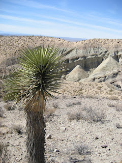
The trail is located north of Barstow at the Owl Canyon Campground launching from campsite #11. The labeled trail is a 2 mile hike through Owl Canyon and it's stark but colorful canyon walls. We however took another tack. About .6 miles up the trail there is a cave that leaves the trail to the right side (east). As we trekked along we entered this cave and followed its narrow 30' dark path to the other side of a hill. We then scrambled up a wash to the ridge above. The view here is amazing as you can see back to the west where Rainbow Basin is located. Rainbow Basin is similar to the painted desert in that it includes rock strata of many colors. From this ridge we hiked into another wash.
This is where the story really gets good. After hiking through to a beautiful view of the Barstow area we attempted to head back the way we came only to discover that every creek wash looked the same and that we were not sure which one we came through. This proposed quite a problem as the ones we attempted ended in 10, 20 and 30 foot drops. After some discussion of how beautiful the area would be during a rainstorm and how much it would really suck to be stuck out in this baren destert with our limited supplies we eventually (2 hours later) found our way back to the main trail.
For the future we have decided to bring matches, space blankets, and more water if we are to undertake the risky endeavour of leaving the trail again.
You may be asking your self at this point, "didn't he have a map and compass?" Well, this is true but if you have ever seen a topographic map you know that there are contour lines which show changes in elevation. A quick look at the map of Owl Canyon will reveal that the elevation changes are so extreme that you almost can't see the map for all the contour lines bunched up together. I did plot our path on our map and I am pretty confident it is accurate, but this did not show us where these cliffs would lie and we had to use a tactic of striking out in many directions which ultimately proved fruitful.
Side note on this: this was my first hike in my new hiking shoes and they are very comfortable and secure.

No comments:
Post a Comment